Spectral Imaging
I've been working in this area since 1995 or so, but most of the output is in student theses, either classified or not.
My first remote sensing student was back in 1994 - Captain. Sturgeon worked with AOTF spectral data from JPL. (Spectral and polarimetric analysis of hyperspectral data collected by an acousto-optic tunable filter system., SPIE, 1994.) Really, she was Phil Durkee's student, but I did most of the software. This was pre-ENVI days!
HYDICE was started by one of my first thesis students, Mark Landers. He eventually went off to a company named SpecTir. As part of a fairly broad interest in spectral imaging, we did a number of studies on statistics in spectral data, and showed that the 'Gaussian' assumption people always make is wrong. Target Spectral Statistics in HSI Scenes
One of my very best students was Marine Captain Marcus Stefanou. He did a survey of the existing statistics based analysis techniques for spectral imagery that is still a reference standard for the field. A Signal Processing Perspective of Hyperspectral Imagery Analysis Techniques. Marcus got fed up with his career path, and moved over to the AF recently. He has to learn to let his hair grow out a bit, but I hear he made Lt. Colonel.
We did some work on bathymetry - we used the hyperspectral character of the HYDICE data to take out bottom reflectance variations, with some success. Bathymetry From Hyperspectral Imagery. Toby Garfield may publish this work someday. Tom Fisher sort of redid Stuffle's thesis, using AVIRIS data. Shallow Water Bathymetry At Lake Tahoe From AVIRIS Data
We did a fair amount of classified work on Long Wave Infrared (LWIR) spectral imaging. In an attempt to break out of the classified arena, I sent Marine Captain Aimee Mares off to the University of Hawaii, to work with Dr. Paul Lucey. She brought home some of the first volcano measurements taken in the LWIR. LWIR Spectral measurements of volcanic sulfur dioxide plumes Previously, Brian Collins (another Marine) had worked with John Hackwell at Aerospace, and did an outstanding job working with SEBASS. Thermal Spectral Imagery Analysis is the SPIE paper from that work. His thesis is here.
For a short time I had a pretty nice deal going with Kip Krebs from the OR department, and Scott Tyo from ECE. Kip got fed up with life at NPS, and left academic completely. That sort of ended our human factors work. Scott, and AF Captain, left the AF. NPS failed to make him a timely offer, so he is now as Asst. Professor at the University of New Mexico. The work with Scott has continued, and we have a nice paper on invariant display strategies. Principal-Components-Based Display Strategy for Spectral Imagery
I think the commercial imagery systems, like Quickbird and IKONOS, are the future of remote sensing. One of our early studies on spectral imaging with IKONOS was a study of the Elkhorn Slough. Terrain Classification in Urban Wetlands with High-spatial Resolution Multi-spectral Imagery,
In the latter half of 2004, I had a post-doc, of sorts, from Taiwan. Brandt Tso came over for a break from his regular duties, and worked terribly hard on spectral imaging, adapting Markov Fields concepts to spectral classification. He took some unique, multiangle observations I had from Quickbird, and looked at angular (BDRF) and texture effects. Here is the SPIE talk. Scene classification using combined spectral, textural and contextual information. The publications on his Markov random field work while in Monterey are: A contextual classification scheme based on MRF model with improved parameters estimation and multiscale fuzzy line process, and Combining spectral and spatial information into hidden Markov models for unsupervised image classification,
My version of the look at the multi-angle data was given at the same conference - Multilook scene classification with spectral imagery
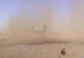
Lately, our big thing is doing terrain classification to avoid helicopter brownout - basically trying to pick landing zones that won't kill the pilots.